
Super El Nino Threatens to Break Climate Records
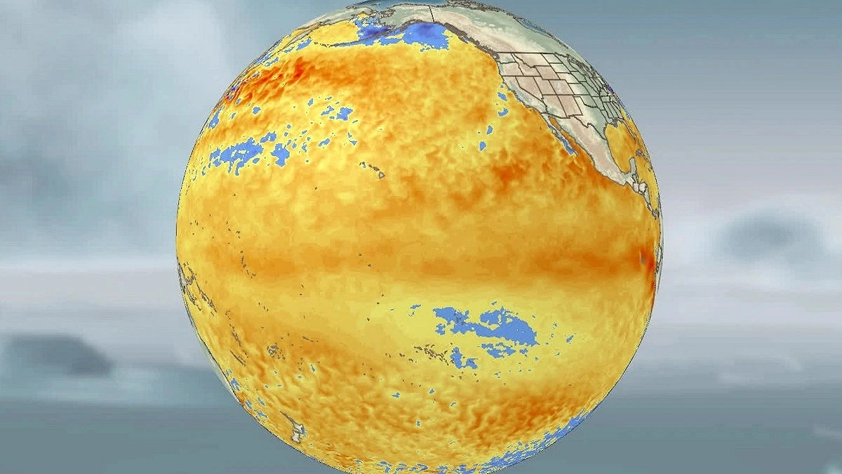
Photo: CNN
El Nino is developing in the Pacific Ocean at a faster pace than expected, raising concerns among meteorologists that it could evolve into a powerful “super El Nino” by this fall or winter and potentially shatter previous climate records.
In its latest update, the Climate Prediction Center of the US National Oceanic and Atmospheric Administration (NOAA) said there is now a two-thirds chance that El Niño will become “strong” or “very strong.”
El Nino is a natural climate cycle that occurs when waters in the tropical Pacific Ocean become warmer than normal, disrupting atmospheric wind patterns and influencing weather conditions around the world.
Its impacts can vary widely. In some regions, El Nino can intensify droughts and heat waves, increasing the risk of wildfires and water shortages. In others, excessive rainfall may trigger flooding. The phenomenon can also weaken the Atlantic hurricane season. At the same time, it may further amplify rising global temperatures already driven by human-caused climate change. The stronger the El Nino, the greater the likelihood of these impacts.
Growing Risk of a Super El Nino
El Nino typically occurs every two to seven years and usually lasts between nine and 12 months. Scientists measure its strength based on sea surface temperatures in a section of the equatorial Pacific Ocean. An increase of more than 0.5 degrees Celsius above average is classified as a weak El Niño, while temperatures exceeding 2 degrees Celsius indicate an extremely strong event, commonly referred to as a “super El Nino.”
Current ocean temperatures remain just below the 0.5-degree threshold. However, the Climate Prediction Center said in its latest monthly report that temperatures could cross that mark as early as next month. As recently as last month, experts had expected neutral conditions to persist through June.
Forecasters now expect El Nino to strengthen throughout the summer and fall. The probability that it will continue through winter has risen to 96 percent.
Experts say a massive volume of warm water has recently accumulated beneath the central and eastern equatorial Pacific Ocean. As that warm water gradually rises to the surface, it is expected to further intensify El Nino.
The Climate Prediction Center said forecasters are increasingly confident that El Niño is on the way, though significant uncertainty remains over how strong it could ultimately become. The likelihood of a “super El Nino” developing between November and January was estimated at 25 percent last month. That figure has now climbed to 33 percent.
Michelle L’Heureux, chief scientist of the Climate Prediction Center’s El Niño and La Niña forecast division, said the chances of a more powerful El Nino would increase further if weakening equatorial winds continue alongside rising ocean temperatures.
Several reliable computer models are also pointing in the same direction, suggesting that this year’s potential “super El Nino” could become the strongest on record. The most powerful El Niño previously recorded occurred in 2015-16. Other “super El Niño” events were recorded in 1997-98, 1982-83 and 1972-73.
Experts say the phenomenon could still become powerful even if it does not reach “super” status. Strong El Niño events typically have a greater impact on weather patterns around the world, although those effects do not always unfold exactly as forecast.
The 2015-16 “super El Nino,” for example, triggered severe drought across the Caribbean as predicted. However, the heavy rainfall expected in Southern California failed to materialize.
Scientists now believe this year’s El Nino could push global temperatures even higher, potentially making 2026 or 2027 the hottest year in recorded history.
NOAA said Monday that this year already has a “very high” chance of ranking among the five warmest years ever recorded, even before the full warming effects of El Nino are factored in.
How Different Regions Could Be Affected
Shifting hurricane patterns: A strong El Nino could reduce the number of hurricanes and tropical storms in the Atlantic basin. In contrast, storm activity could increase in the central and eastern Pacific Ocean, raising the risk of storms in Hawaii and the southwestern United States.
Greater winter impacts in the United States: Winters are typically warmer across the northern United States, western Canada and Alaska during El Nino years, although periods of extreme cold can still occur. Meanwhile, the southern United States often experiences wetter and relatively cooler conditions.
Wet, dry and extreme temperatures: Summer monsoon rainfall could weaken across India and Southeast Asia. El Nino also increases the risk of drought in the Caribbean. Parts of South and East Asia may experience warmer and drier winters. During the Southern Hemisphere summer, particularly between December and February, drought conditions in southeastern Africa could become more severe.
Source: CNN (adaptive)